Malaysia’s perpetual traffic congestion has become an undeniable issue, supported by recent data from mapping software company TomTom. Last year, drivers in Kuala Lumpur wasted an astounding 159 hours in peak-hour traffic, with 75 hours lost to traffic jams. Additionally, commuters spent about RM220 on fuel cost during peak hours.
Our article, ‘Moving Malaysia Forward’ unpacked some of these issues as far back as a year ago. So how can we move the needle forward and solve these challenges?
Understanding the Problem
It’s evident that public transportation is not the preferred choice for the public. To address this, we must delve into the root causes of the problem: the inadequate first-mile/last-mile connectivity and the difficulty commuters face in visualising complete journeys.
The Broken First-Mile/Last-Mile Dilemma
While some fortunate commuters living near public transit stations enjoy the convenience of short walking distances for their first-mile, most are not as privileged. Accessing the middle-mile, where public transport hubs are located, presents a daily challenge.
Comparing Malaysia with pedestrian-friendly public transport networks in Singapore may not be viable. Singapore, a compact urban city-state with a smaller population and land mass, operates public transportation services under a central government, making the comparison untenable given Malaysia’s geographical diversities and varying levels of transport development across states.
Despite suggestions of adding more feeder buses and improving their timeliness, this alone may not suffice. Fixed-scheduled bus services with fixed bus stops do not cater to commuters’ preferences, leading to low ridership, increased costs, and worsened traffic congestion during rush hours.
The Journey Visualisation Predicament
Even those willing to use public transportation struggle to envision their journeys from start to end. Difficulties in accessing bus and train schedules, connecting routes, and delay notifications hinder efficient journey planning.
Current information exists on disparate systems, scattered across various apps and websites, further complicating the situation. The absence of a single journey planning app leaves commuters in different suburbs unable to visualise their entire journey, resulting in a preference for driving instead.
Enter DRT to the Rescue

Changing commuters’ attitudes towards public transport requires innovative strategies rooted in technology and data. To address the first-mile/last-mile challenge, we must encourage the adoption of multimodal transport over single-mode transportation.
In single-mode transit, commuters solely rely on cars, buses, or trains to reach their destinations, with no switching or mixing of transportation modes. Conversely, multimodal transit prioritises mobility, allowing commuters to use various means of transport during their journeys.
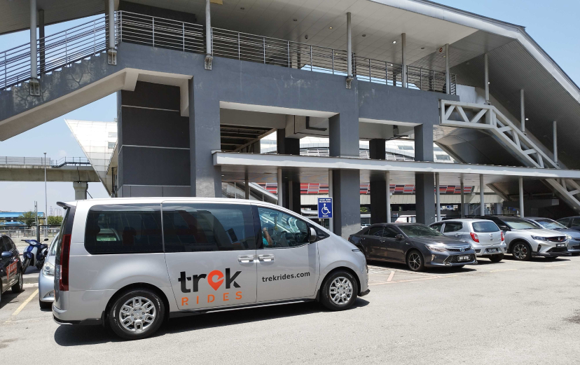
The key solution to promoting multimodal transport lies in Demand-Responsive Transit (DRT). DRT is a novel public transit service that utilises artificial intelligence to intelligently assign vehicles within a geo-fenced zone through a booking app, optimising vehicle operations. This includes standalone multi-purpose vehicles and feeder buses with routes tailored to meet demand.
Visualizing Journeys with a Unified App

Enabling multimodal transit necessitates the availability of journey planning data through a single app. A common platform should publish data from various transport operators, encompassing trains, buses, ride-hailing, and micromobility services. An app with open application programming interfaces (APIs) and agnostic capabilities allows seamless addition of new services from different transport operators, providing commuters with more choices over time.
Plan, Book, Ride, and Pay with Ease
The proposed multimodal journey planner, equipped with personalised travel information, should integrate account-based ticketing (ABT). Unlike outdated stored-value cards that limit seamless travel and create vendor lock-ins, ABT allows users to pay through a commuter-held account. This streamlined process empowers commuters to plan, book, ride, and pay for their trips within a few clicks using a single app.
Addressing Malaysia’s transportation challenges requires the adoption of multimodal transit and sophisticated journey planning technologies. In the upcoming series, Asia Mobiliti will delve deeper into these innovative solutions and explore how technology and data can revolutionise Malaysia’s transport landscape for the better. Stay tuned for more insights and advancements in the transportation industry.
Share This Story!
RELATED POSTS
Malaysia’s perpetual traffic congestion has become an undeniable issue, supported by recent data from mapping software company TomTom. Last year, drivers in Kuala Lumpur wasted an astounding 159 hours in peak-hour traffic, with 75 hours lost to traffic jams. Additionally, commuters spent about RM220 on fuel cost during peak hours.
Our article, ‘Moving Malaysia Forward’ unpacked some of these issues as far back as a year ago. So how can we move the needle forward and solve these challenges?
Understanding the Problem
It’s evident that public transportation is not the preferred choice for the public. To address this, we must delve into the root causes of the problem: the inadequate first-mile/last-mile connectivity and the difficulty commuters face in visualising complete journeys.
The Broken First-Mile/Last-Mile Dilemma
While some fortunate commuters living near public transit stations enjoy the convenience of short walking distances for their first-mile, most are not as privileged. Accessing the middle-mile, where public transport hubs are located, presents a daily challenge.
Comparing Malaysia with pedestrian-friendly public transport networks in Singapore may not be viable. Singapore, a compact urban city-state with a smaller population and land mass, operates public transportation services under a central government, making the comparison untenable given Malaysia’s geographical diversities and varying levels of transport development across states.
Despite suggestions of adding more feeder buses and improving their timeliness, this alone may not suffice. Fixed-scheduled bus services with fixed bus stops do not cater to commuters’ preferences, leading to low ridership, increased costs, and worsened traffic congestion during rush hours.
The Journey Visualisation Predicament
Even those willing to use public transportation struggle to envision their journeys from start to end. Difficulties in accessing bus and train schedules, connecting routes, and delay notifications hinder efficient journey planning.
Current information exists on disparate systems, scattered across various apps and websites, further complicating the situation. The absence of a single journey planning app leaves commuters in different suburbs unable to visualise their entire journey, resulting in a preference for driving instead.
Enter DRT to the Rescue

Changing commuters’ attitudes towards public transport requires innovative strategies rooted in technology and data. To address the first-mile/last-mile challenge, we must encourage the adoption of multimodal transport over single-mode transportation.
In single-mode transit, commuters solely rely on cars, buses, or trains to reach their destinations, with no switching or mixing of transportation modes. Conversely, multimodal transit prioritises mobility, allowing commuters to use various means of transport during their journeys.
The key solution to promoting multimodal transport lies in Demand-Responsive Transit (DRT). DRT is a novel public transit service that utilises artificial intelligence to intelligently assign vehicles within a geo-fenced zone through a booking app, optimising vehicle operations. This includes standalone multi-purpose vehicles and feeder buses with routes tailored to meet demand.
Visualizing Journeys with a Unified App

Enabling multimodal transit necessitates the availability of journey planning data through a single app. A common platform should publish data from various transport operators, encompassing trains, buses, ride-hailing, and micromobility services. An app with open application programming interfaces (APIs) and agnostic capabilities allows seamless addition of new services from different transport operators, providing commuters with more choices over time.
Plan, Book, Ride, and Pay with Ease
The proposed multimodal journey planner, equipped with personalised travel information, should integrate account-based ticketing (ABT). Unlike outdated stored-value cards that limit seamless travel and create vendor lock-ins, ABT allows users to pay through a commuter-held account. This streamlined process empowers commuters to plan, book, ride, and pay for their trips within a few clicks using a single app.
Addressing Malaysia’s transportation challenges requires the adoption of multimodal transit and sophisticated journey planning technologies. In the upcoming series, Asia Mobiliti will delve deeper into these innovative solutions and explore how technology and data can revolutionise Malaysia’s transport landscape for the better. Stay tuned for more insights and advancements in the transportation industry.


